Great Lakes shorelines are retreating. They retreat at various rates. There are few exceptions. These shores consist of cohesive materials (clay and bedrock) that have binding forces, or non-cohesive materials (sand and gravel) that have weak or no binding forces. These shores are composed of rock, fine soil ground up by the glaciers or sediment laid down during much higher lake levels, sand and gravel. Rock is the least erodible and sand the most erodible of these materials. Distribution of these soil types varies along each lakeshore and from lake to lake.
Banks and bluffs are eroded by wave attack, sudden slumping and sliding of massive blocks, and by modest but steady surface erosion. As they erode, the shore recedes. Figures 9 and 10 are good examples of bluff erosion on the Great Lakes.
|

Figure 9 - Bluff Erosion, Sheboygan Cnty, WI
|

Figure 10 - Bluff Erosion, Berrien Cnty, MI
|
Sandy beach ridges, banks and beaches are the exception to the rule of retreat. They advance and retreat as water levels rise and fall, storms come and go and sand supplies shrink or expand. Figures 11 and 12 are examples of a sandy beach and fluctuating water levels.
|

Figure 11 - Beach at Low Water, St. Joseph, MI
|

Figure 12 - Beach at Higher Water, St. Joseph, MI
|
Erosion in rock shores typically involves rock falls where the toe of the bluff has been gradually undercut by wave action.
Erosion rates vary over time and space. These variations occur in response to many factors. Among them are:
- soil slope and composition
- erodibility of material
- lake level
- nearshore lakebed shoals and slopes
- storm wave energy and duration
- precipitation
- ground water and soil conditions
- ice cover
- shoreline orientation
- beach composition, width and slope
- shore protection structures.
Erosion is a natural process. Erosion in one location supplies sand and gravel to build or maintain beaches in other locations. Erosion provides fine sediments that move long distances to settle on the deep lakebed beyond the reach of waves.
Erosion of the lakebed (or downcutting) is a common feature along cohesive shorelines of the Great Lakes (Figure 13) as well as shorelines developed in relatively weak bedrock such as shale and some sandstone.
A key feature of these shorelines is that when erosion of the nearshore lakebed takes place, it is irreversible - it cannot be restored as is the case with sandy shores. The fine sediments and soil are lost to circulate in the lake and settle out in deep water basins.
Sand or gravel may form a narrow beach or a thin layer over the erodible lakebed. Grains of sand and pieces of gravel moved by nearly constant wave motion are abrasives wearing away the lakebed (Figure 14). A thin cover of sand and gravel increases the rate at which erosion takes place through abrasion and the impact of the sediment particles.
|
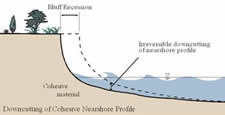
Figure 13 - Downcutting of Cohesive Nearshore
|

Figure 14 - Sand Starved Nearshore
|
If enough sand and gravel accumulates to form stable deposits, it can protect the underlying lakebed from erosion (Figure 15). In one situation, lakebed erosion decreased where there were sand thicknesses greater than 15 centimeters. Erosion during storms will occur even when the sand is quite thick because of the migration of sandbars and the troughs between them. Studies indicate that because of this migration, probably more than 50 centimeters of sand is needed to protect the lakebed from erosion.
With lakebed erosion, any structure built to protect the toe of the bluff is subject to increasing wave energy and to undermining of the foundations as the water depth in front of the structure increases (Figure 16). In areas where bedrock occurs in shallow water, or an accumulation of cobbles and boulders forms a protective lag deposit over the cohesive lakebed, a nearly horizontal platform will develop and this will ultimately reduce the rate of recession of the bluff toe at this location.
|
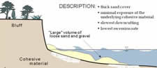
Figure 15 - Sand Rich Nearshore
|

Figure 16 - Undermining of Shore Protection
|
Measurements have shown rates of vertical erosion in the range of one to 15 centimeters per year. More typical erosion rates are three to five centimeters per year. Lakebed erosion rates tend to be highest close to shore where the waves break and where there is lots of turbulence due to wave breaking. Erosion rates tend to decrease further from shore to just a few millimeters per year in water depths greater than a few meters.
The underwater erosion of the lakebed controls the rate at which erosion and recession of adjacent cohesive bluff and bank shorelines takes place. Recession of the bluff or bank takes place as a result of wave erosion of the toe. If this occurred without lakebed erosion then a shallow platform would be left as the bluffs receded and waves would then dissipate all their energy on this platform, thus eventually reducing the ability of the waves to erode the bluff toe. However, as lakebed erosion occurs it continues to allow large waves to reach the toe of the bluff and so lakebed erosion and bluff recession proceed together
The rate of vertical erosion at a point on the profile can be predicted from the profile slope - the steeper the slope the greater the erosion rate, and this accounts for the concave shape of most cohesive profiles with steep slopes close to shore where erosion rates are highest, with the slope decreasing offshore into deeper water as erosion rates decrease.
While erosion of banks and bluffs may decrease during periods of low lake level and increase during high lake levels, the opposite is true of nearshore lakebed erosion. During periods of low lake levels, the nearshore lakebed at a given location is subject to higher water velocities from wave motion and the zone of wave breaking where erosion is highest occurs further offshore than during high lake level periods. When high water levels return, the water depth close to shore is greater than it was during the previous high water period; increasing wave impacts on the shore.